

")
")
")

By Zoë Mason,
Bruce Peninsula Press
On the shores of Wingfield Basin, the lighthouse at Cabot Head has stood watch for over a hundred years. A local landmark, it has been a bike ride destination and a quiet fishing spot for those in the know for generations. However, in recent years, as tourist traffic has increased across the peninsula, Cabot Head emerged from its obscurity – a transformation that has some supporters, but overwhelmingly, a great many vocal detractors.
“Like all politics, though, you never get 100 per cent of the people and you never get zero per cent of the people,” says Jim Wadleigh.

Wadleigh is the sitting president of the Dyers Bay Association (DBA), a community organization tasked with events planning and local decision-making in the village of Dyers Bay. The small beachfront community has borne the brunt of the adverse effects that increased traffic at Cabot Head have produced. While his philosophy of municipal politics is surely sound, the Cabot Head Road issue is one of few that has attracted nearly unanimous agreement – something must change.
“No matter what decision you make, you’re always going to be cheesing off some large group of people. So just do the right thing. There’s no other way around it. That’s the way it is,” he says. “I’ve never seen anything unanimous. On this one, though, the people who have expressed an opinion — and this includes seasonal residents as well as permanent residents — seem to think that maybe that road is becoming less useful than it used to be.”
Trespassing, tourists and traffic
The road was originally constructed in the 1960’s as an alternative access route for lightkeepers who had previously been shuttled in by boat or hiked in via a woodland trail. However, the road was a controversial affair from the start.
“I heard it described this way: they gave the lighthouse keeper a bulldozer and said, ‘put a road here,’” says Wadleigh. “The Crawfords have not favoured having that road. Although I don’t know if it was lack of resources or whatever, but the road just stayed there.”
Ned, one of the aforementioned Crawfords, shines a little more light on the road’s history.
“Harry Hopkins was the lighthouse keeper at the time, and the lighthouse service, somehow or another, got a Caterpillar Tractor and took off and built the road, without our knowledge or permission. We came up here and the road was built,” says Ned Crawford.
The Crawfords – Ned and his wife, Mary – have been one of three primary landowners in the region that bridges Cabot Head, Dyers Bay, and Gillies Lake. Ned’s family acquired the property in the late 1940s. Despite it being private property, there was no consultation with the family when the initial road was built through their land.
“When it first occurred, we said ‘oh, no big deal, Harry needs to get in there.’ It didn’t really impact as much because there wasn’t a lot of tourist traffic at the time. So we didn’t make an effort. And then after it got established, I just don’t have enough money to pay an attorney to go against the municipality and pay their attorney with my taxes. It’s been a battle for years and years, but the bottom line is, it’s a trespass road.”
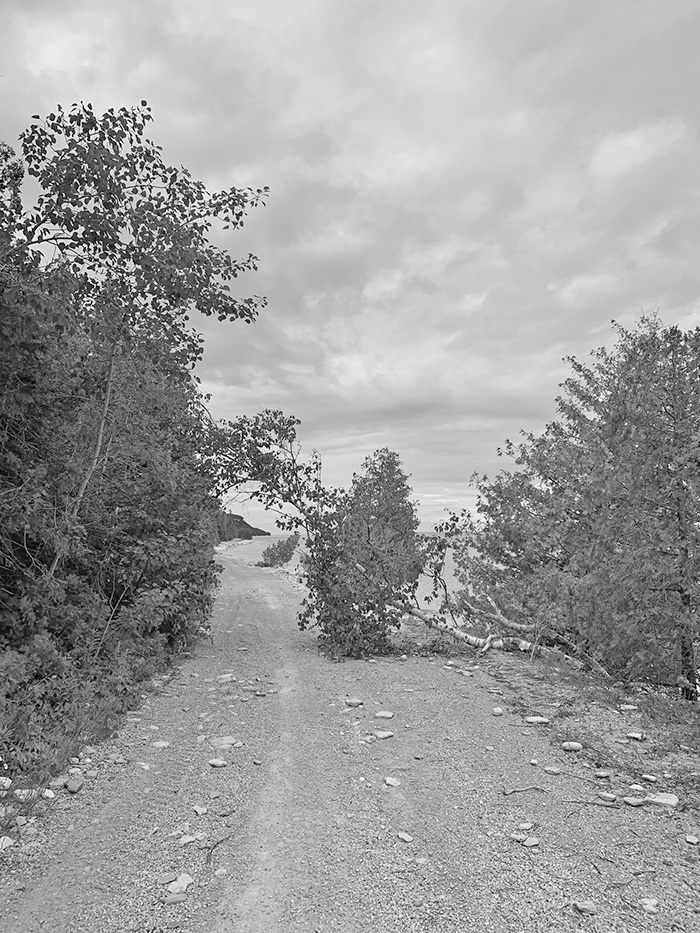
At the time, the road was unproblematic enough to be ignored and utilitarian enough to be justified. Until the 1980s, Cabot Head lighthouse was fully operational, but today, the lighthouse exists only as a museum. As tourist traffic increased, it amplified the damaging consequences of the road, both for the Crawfords and for the residents of Dyers Bay.
Perhaps more than anyone, the Crawfords have been hyper aware of the increasingly destructive corollaries of the road.
“It just really pisses us off because we have been ignored as property owners
for fifty-plus years. The problem with the tourist traffic – other than the fact that it is a deathtrap road and it’s just a major accident waiting to happen – is that we’ve had a lot of problems with people camping and leaving garbage. We used to ride our bikes a lot up there, and you can’t now, you can’t walk there safely anymore, the volume of traffic is just horrible,” says Ned Crawford.
“I think the other thing that really bugs me is you know how badly the road has been damaged in the last couple of years with all the storms and that. It’s eroding away. To spend tax dollars to fix that up when there’s a lot of other priorities that the municipality has, as well as the government, and even more now with the stress of a pandemic, to fix up that road is outrageous, it just doesn’t make any sense,” adds Mary.
In Dyers Bay, enthusiasm for any of the proposed road repair is equally as low.
“One of the issues the traffic has raised is safety,” says Wadleigh. “We have a winding road with no sidewalks. It’s our main street, but it’s our only street. People use it to go for a walk, to walk the dog, to see the neighbours, to bike to the dock — there are about 100 cottages between the hill and the end where it splits, and it’s narrow and it’s just not suitable for volumes of traffic. It was never designed for that.”
“Ten years ago, we built our new home and had to move our belongings from one side of the road to the other. When we were trying to move things across the street, the traffic was so heavy we would have to wait minutes, sometimes, before we could cross, it was hectic,” recalls Marilyn Hudson, a long-time seasonal resident.
“My cottage is right before that S curve (on Dyers Bay Road). You can barely get two cars by there and people drive way too fast,” says another resident, who’s been in the area for fifteen years. “Even for local traffic, it’s dangerous, nevermind the amount of people that pass through. That road is not meant for high volumes of traffic.”
It’s not only the inconveniences presented by tourist traffic that is luring the people of Dyers Bay towards a rare unanimity. They’re also incentivized by the pleasantries that they have discovered or rediscovered in the absence of traffic since the lighthouse’s closure for maintenance in 2017.
“Coincidentally, just about the time that the road was closed to traffic, we had a huge turnover of cabins. We had at least 20 new families move into the Bay, and the most wonderful thing happened! We all met each other quickly and they became part of the Bay very quickly, as, without the traffic, people used the road as part of the hamlet. We live on the road now, and our local traffic is careful and considerate of us. I am afraid the Cabot Head traffic was less so,” says Hudson.
Reopening and resistance
Unfortunately for those who have grown accustomed to the quieter Bay, whispers of reopening have become increasingly frequent.
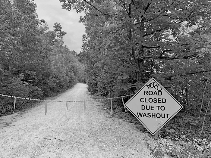
The lighthouse, which was closed in 2017 when mercury was discovered in the building and the surrounding soil, was slated to reopen this season before a leaky roof delayed repairs and a series of winter storms made the road impassable. While the repairs are an easy hiccup to overcome, the road has — as it has many times before — presented a more complex dilemma.
In Dyers Bay, several solutions to the traffic issue have been put forth to the DBA, but none seem to have gained traction in a significant way.
“One of the solutions we proposed was a shuttle bus,” says Wadleigh. “So you’d bring people down, don’t let them into the village somehow, tell them, ‘if you’re going to Cabot Head, you must park here, you must get on the shuttle bus.’ So the municipality put out a tender document in the [Bruce Peninsula] Press.”
Wadleigh says that although one offer was put forth to create this shuttle service, nothing ever came of it as interest tapered off.
“That was while the light station was closed. So it was an opportunity to do it while it was closed and come up with a well thought out plan and not be rushed. But partly because the reopening was so delayed, they didn’t get any serious offers. I think there were only two long weekends left in the summer and they couldn’t put a business plan together. Well, it’s all tourism stuff, right? You gotta make hay while the sun shines.”
Of course, even if the shuttle bus plan had come to fruition, Mother Nature would have interrupted them. With water levels at record heights, this winter’s round of storms ravaged Cabot Head road, which runs along the shoreline. The road is now closed altogether. While this might postpone the suffering in Dyers Bay, the Crawfords are already grappling with the next steps.
“There is no easement, and there is no governmental agency that has any right. Oceans and Fisheries is making some noise now about the road, too, and I’m fighting them at this time. There is no legal right for anybody, any governmental body, to go and build the road. Technically, its expropriation,” says Ned Crawford.
The noise Crawford is referring to came in the form of a recent article in the Owen Sound Sun Times, which outlines the municipality’s decision not to renew the lease on the Cabot Head property barring federally-funded repairs on the road — a call which Oceans and Fisheries Canada appears to be answering.
“When we saw that article that appeared in the Sun Times a few weeks ago on June 5, that’s when we first became aware that they had any plans of doing anything with the road,” says Mary Crawford. “They never approached us.”
Fixing the Road to Nowhere
In an email to the Press, Michael Niziol, a Communications Advisor at Fisheries and Oceans Canada, wrote that “Fisheries and Oceans Canada is aware of the concerns of some land owners and will continue to consult with those interested parties, along with the Municipality, when and if plans for the site move forward.”
In Dyers Bay, the cost offers additional deterrence for reopening the Cabot Head road.
“There were many petitions put forth to try to get the municipality who is responsible for it to build a road North of Dyers Bay, like cut a road through the (forest), which again is a huge engineering feat, massive cost,” says one long time resident. “As a resident, we vote extremely no.”
“The initial estimate from the municipality when they went out and looked at the road last fall was hundreds of thousands of dollars, and no real parameters around that. Is that a road that’s going to be there forever? Probably not. Because it’s suffered more damage since then,” adds Wadleigh.
“It sounds like the water levels are going to continue to go up for the next few years. So whatever it is, it’s going to be very expensive. And as a taxpayer in the municipality, look, people with social needs, housing needs, mental health support, and all the things that municipalities are responsible for these days, you know, fixing a road to nowhere really isn’t (high on the list of priorities).”
Since this past winter’s storms did more damage to the already dilapidated road, estimates for the cost of repair are even higher.
“Fisheries and Oceans Canada is considering funding the road repairs (estimated $1,000,000) for the Cabot Head lighthouse site from departmental funds. We do not currently have a specific timeline for the funding approvals for this project and it will be evaluated over the course of the next two years along with several other departmental priorities requiring funding,” wrote Niziol.
“We are still in the investigation stage,” added Public Works Manager Troy Cameron in an email to the Press. “The cost is dependent on future needs of the road and if it is to be rehabilitated to previous conditions or constructed to a standard that would withstand future high water levels.”
But for the parties concerned, the hope is that any investigations remain just that. A popular alternative proposal is turning the road into an ATV or human-powered activity trail. Even the Crawfords agree that a hiking trail or a similar conversion is the best outcome they’re likely to receive. If properly patrolled, they say, they’d be open to it.
But Wadleigh cites emergency access and lighthouse maintenance as possible stumbling blocks for the compromise. In a perfect world, Wadleigh says Cabot Head would be absorbed by the National Park and maintained accordingly. The Crawfords’ dream is a little more grounded: keep the road closed.
“The families have protected the lands along the shore road and around Gillies Lake from development for over 70 years. The reason these areas are so beautiful is due to our ownership and conservation efforts. We get little recognition of this and often adverse reactions to owning this acreage and waterfront and restricting access to it. There have been opportunities to subdivide which we have not done because we wanted the land to remain in a natural state,” says Mary Crawford.
“It’s in our blood, and that’s why we’re so protective of it.”


